Friday, June 24, 2011

Rer C

The rer C is the more sprawling rer line, it connects Pontoise,Versailles-Rive-Gauche, Saint-Quentin-en-Yvelines, Versailles Chantiers, Massy-Palaiseau, Dourdan-la Forêt and Saint-Martin-d'Étampes.
All the trains don't go by those terminus, and some never go by those terminus, they have their own terminus.

Each destination is related to a different name for the rer.

The rer C train serves all the Paris zone, with 16 stations in Paris (zone 1) from Porte de Clichy to Bibliothèque François Mitterand, as well as Javel and Pont-du-Garigliano. You can use your ticket t+ within this zone.

The frequency depends on the branch, destinations, days of the week, the hours of the day, off-peak hours or rush hours.

In rush hours, for the common journey, you can have train every 2-3 minutes, just to have an idea of the frequency, however it doesn't mean a lot because, the train may not to go on the desired location.

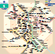
Here is the rer C map.


To have a better understanding of the zone covered by this Paris train line, you can check the Paris zones map (you can also find those two maps on the Paris rer map post).

The rer C is a widely used line for tourism purpose because a lot of different attractions are located on this line. Indeed you can go and visit the Tower Eiffel, le Pont Mirabeau, le Champs de Mars, le Trocadéro, les Invalides...

The rer C  is connected with the rer B in 3 stations and with the rer D in 1 station (Juvisy).

Wednesday, June 22, 2011

Paris zones map

The Paris zones map indicates the 6 different Paris zones with the connections between rer and other transilien (Parisian suburban railway network) lines.
Paris zones map
Paris for rate purposes is divided by zones, 6 Paris zones currently coexist until July 2011, after this deadline, it will be 5 zones.

Those zones are concentric around the zone 1, where you can find the major touristic places; to visit Paris. In Paris intra-muros, the ticket t+ is sufficient (whatever distance).

Except for the metro, for which, even if you go to the zone 3 (Grande Arche de la Défense for example), you are allowed to pay only a single ticket t+, you have to be careful to respect the Paris zone legal fare to avoid fine.
You can use the pass, that you bought to use this particular public transportation (Navigo, Paris visite, origin-destination ticket...).

The Paris zones map is valid for the different public transportation in Paris (tramway, bus, noctilien, metro, rer, transilien).
Even if this map shows only the rer and transilien, the Paris zone fare are available for buses and tramways as well, outside the zone 1.

On the Paris zones map, you will see in the middle Paris city (zone 1) with some stations (Champs de Mars, for example).
There are also some other ''touristic'' places if you schedule to visit Paris by train:
-Disneyland parc is on the zone 5.
-Charles de Gaulle airport is on the zone 5.
-Orly airport is on the zone 4, however it may have a special fare (by the Orlyval).
-''La Grande Arche de la Défense'' is on the zone 3.
-The 6 majors railways stations (Gare du Nord, Gare de Lyon, Gare de l'Est, Gare d'Austerlitz, Gare Montparnasse and Gare Saint-Lazare) are in the Paris zone 1.

You can notice on the map:
-The RER lines, rer a, rer b, rer c, rer d and rer e.
-The different connections between rer and other transilien lines.
-You have the shuttle bus Orlyval going from Antony station to Orly Airport.
You can also see the transilien network with the lines going by the major railways stations and the Parisian suburbs, on the Paris zones map. The transilien network covers all the Paris zones to connect Paris to some of its suburbs.

Thursday, June 16, 2011

Rer B

The Rer B connects Airport Charles de Gaulle 2- Mitry-Claye (north-east) to Robinson- Saint-Rémy-lés-Chevreuse (south) through Paris. The rer train has other terminus because all the trains don't stop at those 4 terminus but may have their own terminus.

Above is the Rer B map (that you can find also in the Paris rer map section):


It gathers 47 stations whose 7 of them in Paris (zone 1).
Those 7 stations are Gare du Nord, Châtelet-les-Halles, Saint-Michel-Notre-Dame, Luxembourg, Port-Royal, Denfert-Rochereau, Cité Universitaire. Beyond those stations, you can't use your ticket t+.

The first departures of the Rer B occurs around 4:50am.
In rush hours, you may have trains every 3 minutes (the 2 ways), on the common branch, however you can have trains every 30 minutes late the evening and depending on the branch.

As other Paris rer, you have also trains which skip some stations, so be careful to watch the screens on the station to have more information.

At Gare du nord, there is a connection with the rer D and the rer E.
At Antony station, there is a connection with the Orlyval, the shuttle which goes to Orly airport. Furthermore, one of the rer B terminus is Charles de Gaulle airport 2 (stops also at the terminal 1).

Saturday, June 11, 2011

Rer A

The Rer A terminus (ending lines) are:
Saint-Germain-en-Laye - Poissy - Cergy-le Haut - Boissy-St-Léger - Marne-la-Vallée- Chessy.
However there are other terminus on those lines, a train can go from one station to another of those lines without reaching those terminus.

Here is a map of the Rer A, you may also check the Paris rer map.


If you use a ticket t+, you can only travel between Charles de Gaulle-Etoile et Nation, beyond you need another pass.
The rer A has only one station in the zone 2 (Vincennes Station), You can't use your ticket t+.

The frequency of the Paris train depends on the branch, on the hour of the day, the day of the week, the period of the year, the type of day (normal day or public holiday)...

In rush hours and for the common section, the frequency can reach 2 minutes from east to west, and around 2.5 minutes in the other way. 
The rer A frequency can reach 20 minutes on the week-end and holidays, or even 30 minutes for off peak-hours, depending on the branch.

Thursday, June 9, 2011

Paris rer map

When refering to the Paris rer map, we talk about the different RER maps which include, the rer a map, the rer b map, the rer c map, the rer d map, the rer e map and  the rer maps which gather every single Paris rer map.


Here you will find the printable pdf Paris rer map for each line, click on the images:


RER A map


RER B map


RER C map


RER D map


RER E map


Also, you have the Paris rer map pdf format showing all the different pay zones. You can only use your ticket t+ in the zone 1. The Paris zones map is an important map to help you avoid fines in case of controls.


You can choose to print a Paris rer map showing the different connections with the metro and  tramway, you can use the Paris subway map above (pdf format).


You can find the rer a map, rer b map, rer c map, rer d map, rer e map, the Paris subway map as well as the Paris zones map on the Ratp website and Transilien site.

Sources: Ratp -Transilien

Saturday, June 4, 2011

Paris subway map pdf

The Paris subway map will help you find your direction in the Paris subway.
By line, it shows you the different directions and connections (without details), the entire map is a mixing of all the maps.
Also, there are no Paris subway map in English, however this won't prevent you from visiting Paris, the french map and the different signs in the metro are easy to understand.

Here are the Paris subway maps pdf format:
 
Paris metro map line 1 pdf -          
Paris metro map M2 -             
Paris metro map line 3 -         

Paris metro map M3-bis pdf - 
Paris subway map M4 pdf -
Paris subway line 5
Paris metro map line 6

Paris metro map line 7 pdf -
Paris metro map M7-bis pdf -
Paris metro map M8 -

Paris subway map M9 pdf -   
Paris metro map line 10 pdf -
Paris metro map M11 -

Paris subway map  line 12 pdf - 
Paris metro map line 13 -
Paris metro map line 14 -

The Paris subway map of the entire network will show you all the connections, between the metro, rer and tramway. The black signs (like a spanish tilde ñ) (close to the 2 different colors) show the limit area beyond which you can't use a single ticket t+ for the rer. The white signs (small and large) are hubs.
Paris subway metro map with connections


If you don't have a map already printed, you can pick one at the entrance of the different Paris subway stations while visiting Paris.

Tips:
*there are signs alongside the metro to guide you regarding exit and connections.
*don't forget there are no Paris metro maps in english

Paris metro 11

The Paris metro 11 connects Châtelet (straddles the 1rst and 4th arrondissements of Paris, in the south-west) to Mairie des Lilas (town of Lilas in the north-east).

The entire journey lasts around 16 minutes. The Paris subway serves only 13 stations, it's one of the shortest line of the network.
From west to east, 1 first departure occurs at Châtelet station at 5:30am.
In the other direction, 2 first departures, 1 at Mairie des Lilas at 5:30am, the 2nd one at Place des fêtes at 5:31am to Châtelet.

The last departures between the two major terminus are respectively at 00:59am to Châtelet and at 00:56am to Mairie des Lilas.

The frequency of the Paris metro 11, for the week is, before 7:30am around 4-5 minutes, between 7:30am and 8:30pm it's around 2-4, and after this hour, it's around 5-6 minutes.
The frequency are less on saturday and sunday and can reach 10 minutes on some nights (friday-saturday, saturday-sunday, night before holidays-holidays).

Places to visit with the Paris metro 11
At Châtelet station you can visit the forum des Halles.
Rambuteau station allows you to visit the Centre Georges Pompidou.

Related articles:
 Paris metro line 1
 Paris metro line 2
 Paris metro line 3
 Paris metro line 3bis
 Paris metro line 4
 Paris metro line 5
 Paris metro line 6
 Paris metro line 7
 Paris metro line 7 bis
 Paris metro line 8
 Paris metro line 9
 Paris metro line 10
 Paris metro line 11
 Paris metro line 12
 Paris metro line 13
 Paris metro line 14

Paris metro 5

The Paris metro 5 connects Bobigny-Pablo Picasso (north) to Place d'Italie (south). Bobigny-Pablo Picasso is located in the town of Bobigny whereas Place d'Italie is located in the 13th arrondissement of Paris.

It's a 34 minute journey from the north to the south and a 33 minute journey from the south to the north.
2 circulations occur in the 2 ways, one at 5:30am from Bobigny-Pablo Picasso and the second one from ''Eglise de pantin'' station (except on saturday, sunday, holidays) at 5:31am to the south; from the south to the north, one departure is at 5:30am from the terminus Place d'Italie, the second one from Gare d'Austerlitz (every day) at 5:32am.

The last departures of the Paris metro 5 is at 00:41am from the north and at 00:42 from Place d'Italie, during the week.
During the nights of friday-saturday, saturday-sunday, night before holidays-holiday, the last departures are respectively at 1:41am and 1:42am.

During the week, the frequency is 4-5 minutes before 7:30am, from 2-4 minutes between 7:30am and 8:30pm, after 8:30 the frequency is 6-7 minutes.
The frequency decreases during the week-end and can reach 10 minutes on friday-saturday, saturday-sunday, night before holidays-holiday.

Place to visit with the Paris metro 5
The Porte de pantin station allows you to visit the ''Parc de la villette', one of the most popular park in Paris. 
If you plan to visit the ''Parc des buttes Chaumont'', stop at Laumière station.
You can go to the ''Gare du Nord'', ''Gare de l'Est'', and ''Gare d'Austerlitz  by stopping at the corresponding stations.
Bastille station will allow you to see a symbolic place in Paris, the ''Place de la bastille''.

Those are some places that you can visit. By using the connections between the different Paris metro and the Paris metro 5, you will have a larger range of possibilities to visit Paris.

Related articles:
 Paris metro line 1
 Paris metro line 2
 Paris metro line 3
 Paris metro line 3bis
 Paris metro line 4
 Paris metro line 5
 Paris metro line 6
 Paris metro line 7
 Paris metro line 7 bis
 Paris metro line 8
 Paris metro line 9
 Paris metro line 10
 Paris metro line 11
 Paris metro line 12
 Paris metro line 13
 Paris metro line 14

Paris metro line 14

The Paris metro line 14 connects Saint-Lazare (north-west) to Olympiades (south-east). It's a fully automated line with 9 stations.

The line 14 doesn't go to the Parisian suburb, it serves only some arrondissements of Paris, the 8th, 1st, 4th, 12th and 13th.

The entire journey lasts around 13 minutes.
The first departures occur between 5:29am and 5:35am; Despite the short length of the line and because of the automation of the Paris subway line 13, there are departures:
-to the west: At Olympiades, Bibliothèque François Mitterand, Gare de Lyon and Châtelet.
-to the east: At Saint-Lazare, Châtelet and Gare de Lyon.

The last departures at the two major terminus and for the entire journey occur at 1:00am and 1:01am. On some nights (friday-saturday, saturday-sunday, day before holidays-holidays), the last departures are 1 hour later.

The frequency are around 2-5 minutes generally, for the whole week.

To visit Paris by the Paris metro line 13,you can stop at Châtelet or Pyramides stations.

Related articles:
 Paris metro line 1
 Paris metro line 2
 Paris metro line 3
 Paris metro line 3bis
 Paris metro line 4
 Paris metro line 5
 Paris metro line 6
 Paris metro line 7
 Paris metro line 7 bis
 Paris metro line 8
 Paris metro line 9
 Paris metro line 10
 Paris metro line 11
 Paris metro line 12
 Paris metro line 13
 Paris metro line 14

Paris metro line 13

The Paris metro line 13 links Châtillon-Montrouge (south) to Asnières-Gennevilliers les Courtilles (nord) and Châtillon-Montrouge to Saint-Denis-Université (north). There is a common section until la Fourche station.
Those stations hold the name of the towns that the metro serves,  they are located on the Parisian suburb, however this subway goes through some arrondissements of Paris.

The journey trip:
-to Asnières lasts around 36 minutes and 37 minutes the other way.
-to Saint-Denis around 38 minutes and 40 minutes the other way.
The Paris metro line 13 is overloaded by an important traffic of travelers.

The first departures occur from the major terminus at 5:30am, except from Châtillon to Asnières, the departure is at 5:35am. There are no other first departures from other stations (only from the 3 terminus).

The Paris metro 13 last departures are:
-to Asnières is at 00:40 am on the week.
-to Saint-Denis is at 00:37 am for the week.
-from Asnières is at 00:37am for the week.
-from Saint-Denis is at 00:36am for the week.
On friday-saturday night, saturday-sunday night, day before holiday-holiday, the lasts departure occur generally 1 hour later compared to the week (except to Asnières, it's at 00:46am).

At the ''fourche station'' there are directional signs for a special station with 3 quays, on 2 levels.

The frequency of the Paris metro line 13 is around 2-3 minutes before 8:30pm, and 5 minutes after 8:30pm, for the week and for the common section.
The frequency  from/to Asnières to/from La fourche and from/to Saint-Denis to/from La fourche, are the same, 4-6 minutes before 8:30pm, and 9-10 minutes after 8:30pm, for the week.

For the week-end and for the the individual sections, the frequency can reach 12 minutes, after 8:30pm.
- it's a range of 6-7 minutes between 7:30am-8:30pm, between 9-12 minutes otherwise.
-there are more trains for the common section, the frequency is around 3-5 minutes.  

To visit Paris by the subway line 13
At Saint-Denis Porte de Paris, you can go to the Stade de France.
You can walk and go to the Champs-Elysées, visit the Grand and Petit Palais and also go to the Gare Saint-Lazare.

With the Paris subway map you will have a better understanding of the Paris metro line 13 while visiting Paris.

Related articles:
 Paris metro line 1
 Paris metro line 2
 Paris metro line 3
 Paris metro line 3bis
 Paris metro line 4
 Paris metro line 5
 Paris metro line 6
 Paris metro line 7
 Paris metro line 7 bis
 Paris metro line 8
 Paris metro line 9
 Paris metro line 10
 Paris metro line 11
 Paris metro line 12
 Paris metro line 13
 Paris metro line 14

Gare du Nord

In terms of passenger traffic, the Gare du Nord is the major railway network SNCF (grandes lignes). It's located in the 10th arrondissement of Paris.

The trains run locally, nationally and internationally.

Internationally, the trains go to the United kingdom via Eurostar, to Belgium, Germany and the Netherlands via Thalys.

Nationally, it's the major station to go to the North, the french regions North-Pas-de-Calais and Picardie (North of France), the trains from Gare du Nord serve the majority of the big agglomerations of those 2 regions.

Locally, the RER B goes on the platform 42 (to the south)  and 43 (to the north) while the RER D goes on the platform 41 (to the north) and 44 (to the south).The platforms pull in the four-lane underground stations
The frequency can reach 3 minutes for the RER B, in rush hours and 5 minutes for the RER D.
At ''Gare de Magenta'', the RER E is connected to the Gare du Nord by an underground access.

You can also go and visit Paris from/to the Gare du Nord by the Paris metro line 4 and the Paris metro line 5, by stopping to the Gare du Nord station. The traffic is heavy with a frequency of 3-5 minutes during the day for the metro line 4, and 2-4 minutes for the metro line 5, for the week.
The Gare du nord is also connected with the Paris metro line 2,  via a connecting corridor between Chapelle station (line 2) and the underground part of the Gare du nord.

In addition to those trains, you can also visit Paris from the Gare du Nord by bus, Paris l'Open tour, the Noctilien bus (bus by night), as well as some lines of the transilien (H and K, the transilien is the SNCF railways network).

Friday, June 3, 2011

Paris subway map

The Paris subway map is a detailed guide for travelers while taking the commuter trains in Paris. The Parisian network metro gathers 16 lines, from 1 to 14 with 2 minors lines (3 bis and 7 bis), with 300 stations (384 stops).
The different lines connect between them and other trains, to cover Paris and some towns located in the suburb.


Above are the Paris subway map for each line:

            Paris subway map line 1
Line 1: La Défense/ Château de Vincennes
25 stations

Paris subway map line 2
Line 2: Porte Dauphine / Nation
25 stations

Paris subway map line 3
Line 3: Pont de Levallois – Bécon / Gallieni
25 stations

Paris subway map line 3bis
Line 3bis: Gambetta / Porte des Lilas
4 stations

Paris subway map line 4
26 stations

Paris subway map line 5
22 stations

Paris subway map line 6
28 stations

Paris subway map line 7
8 stations

Paris subway map line 8
37 stations

Paris subway map line 9
37 stations

Paris subway map line 10
13 stations 

Paris subway map line 12
28 stations

Paris subway map line 13

The different lines have connections with the RER(s), with the funiculaire of montmartre, with buses and tramways. 
Above is a printable copy of the whole Paris subway map for the 16 lines, you will have a better understanding of all the different connections. Paris subway map  

SourcesWikimedia commons (M00tty)

Thursday, June 2, 2011

Paris train stations

The Paris train station Gare du nord is located on the zone 1 of the network, so you can use your ticket t+, for the rer (within the zone 1) and/or the metro (wherever you go, there is no limitation zone for the metro) to visit Paris.

The train station is located on the 10th arrondissement of Paris.

The entrance hall allows you to access the ''train grandes lignes", Thalys, TGV and to access the Eurostar terminal (level 1).
In the north, the Paris train station Gare du nord is entirely opened to welcome the traffic.

The south of the principal hall gives access to some stations bus, you can find at this place stores and counters.

In the west side, there are access to catch a taxi; it's also the direction to the Eurostar platform in the first level (it's a secure zone, England doesn't belong to the Schengen area).

If you plan to visit Paris by the Parisian metro and the RER, you may choose to go by the east side of the entrance hall of the Paris train station. Here is the regional underground gare.
You will have access to the RATP bus terminal, a partially covered train platform (francilien), and also the RER B, the RER D, the Paris metro 4, the Paris metro 5 located on the basement.
You will find on your way the entrance turnstiles, and there are also the billeterie Ile-de-France, those are the vending machines to buy your different tickets to visit Paris by rer, metro, tramways and bus.

Two halls connect the Gare du nord railway station to the Gare de Magenta, the RER E station.

You will find also different tickets machines, depending on the transportation service that you use, in the Paris train station Gare du Nord.
Related Posts Plugin for WordPress, Blogger...