Here is a map of Orlyval and its connection with the RER B.
Orlyval is a metro which allows you to go from/to Orly-- to/from Paris.
The yellow-grey line represents the trajectory, Orly south, Orly west, and the terminus ''Antony''.
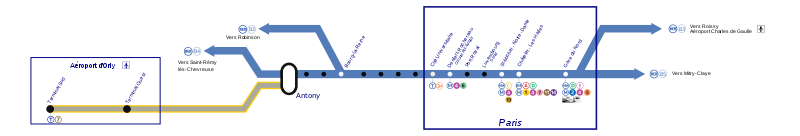
By Hektor(www.creativecommons.org/licenses)- Orlyval map
The RER B goes:
-from/to Saint-Rémy-lès-Chevreuse-----> to/ from Roissy Aéroport Charles de Gaulle.
-from/to Saint-Rémy-lès-Chevreuse-----> to/ from Mitry-Claye.
Between Antony and Mitry-Claye stations or Antony and Roissy Aéroport Charles de Gaulle stations, you reach Paris.
You have different stations in Paris, from Cité universitaire to Gare du Nord, indicated on the rectangle.
The RER B is also the only train connecting to Orlyval.
No comments:
Post a Comment