Wednesday, August 31, 2011

Bois de Vincennes

History and description
The former name of the Bois de Vincennes was "Vilcena".
Since the 11th century, it was used for royal hunts. After it was abandoned for some time, in the 18th century the king Louis XV decided to reforest the deserted park.
The reforestation ended in 1731, the wood became a promenade open to everybody, except for servants and cars.

After 1794, it was a military place and was used like a prison. It suffer from numerous damage at this time.

In 1860, the City of Paris manage the Wood, and Napoleon III decided to transform it into a public park.
The engineer Alphand transformed the wood into a vast landscape park, as he did for the Bois de Boulogne.
Despite all those efforts, during the war of 1870 the wood was damaged. And it's only after the second war world that the City of Paris launched a massive reforestation plan.

Today, the Bois de vincennes is a 995ha area park, wooded for half part, it's also the biggest green space of Paris. It houses several nice places to visit like the zoo de vincennes, the château de vincennes, the parc floral, the Arboretum de l'Ecole Du Breuil...
Also there are 4 lakes to beautify the site:
*the "lac de Gravelle"
* the "lac des Minimes"
* the "lac Daumesnil", the biggest with 2 islands (the island of Reuilly and the island of Bercy)
* the "lac de Saint-Mandé"

There are playgrounds for children, carousel, cycle path, bridleways, theatre guignol, boat trip, guided tours...

La Maison du Parc et du Bois, located at the entrance of the Parc Floral (near Château de Vincennes), provides information on all activities, events, concerts, exhibitions taking place in the Parc floral and the Bois de Vincennes.

Location of the Bois de Vincennes
The Bois de Vincennes is located in the 12th arrondissement of Paris.


How to get to the of the Wood
To go to the Wood:
* you can use the Paris metro line.
-Paris metro line 1: Château de Vincennes station, Saint-Mandé-Tourelle, Bérault stations
-Paris metro line 8: Charenton-Écoles, Liberté et Porte Dorée stations

* You can use the Paris rer line:
Paris rer A: Vincennes, Fontenay-sous-Bois, Nogent-sur-Marne and Joinville-le-Pont stations


Entrance fee and opening hours
The Wood is a free-admission place and is opened 365 day a year

The Bois de Vincennes map

Monday, August 29, 2011

Bois de Boulogne

History and description of the Bois de Boulogne

More than 20 centuries ago, the place was a huge forest called the forest of Rouvray.
It became also a place where some monasteries was built and a former hunting ground for the kings of France.

In 1852, under the reign of Napoleon III, the place was convert to a park.
The works was done by Varé who was quickly fired and replaced by the engineer Alphand and the landscape designer Barillet-Deschamps, the Baron Haussmann led the works. The Wood became also a fashionable promenade.

Today the Bois de Boulogne is a 846 ha park (2.5 times bigger that Central Park, New York)located in the west side of Paris city.
It holds pleasant walkways, bridle paths, boating on the lake, bike trails...

In addition of several lakes, ponds and streams, the Bois de Boulogne welcomes the Parc de Bagatelle, the Jardin (garden) du Pré-Catelan, the Jardin d'acclimatation, the hippodrome de longchamp...as well as more than 400 000 trees.

Location of the Bois de Boulogne
It's located in the XVI arrondissement of Paris.

How to get to the of the Bois
To go to the Wood, you can use the Paris metro line 10 or Paris metro line 2
Line 10: Porte d’Auteuil station
Line 2: Porte Dauphine station
It's possible to go by the Paris metro line 1:
- Porte Maillot station + bus or small train
- Pont de Neuilly station + bus.

Or
the Paris rer line Porte Maillot or Avenue Foch station (rer C)

Entrance fee and opening hours
It's a free-admission Paris park and it's not closed.

The Bois de Boulogne map

Sunday, August 21, 2011

Paris park, Parc de la Villette

History and description of the Parc de la Villette

The idea of a Park on the site of the former general abattoirs of Paris, came little by little after the destruction of the place in 1974.

In 1983, a French architect, Bernard Tschumi became responsible for the architectural conception, after an international competition for the architectural design of the park started in 1982.

Today the Paris park combines nature and architecture, recreation areas, places of exhibitions, performances and debates...with inside "la Cité des Sciences et de l'Industrie", "la Maison de la Villette", "la Géode", "Zénith de Paris", "l'Argonaute"...on an area of 55 hectares (33 ha of green spaces).

The park houses 12 theme gardens:
*Les jardins passagers: the gardens are ecological gardens for educational, pedagogical and social purposes.They germinated in 2001.

*Le jardin des bambous- the garden of bamboos houses the second largest collection in France of species of bamboo. The garden is located six feet below the rest of the park, a mixing of black and white pebbles between bamboo stems dark or light embellish the garden. At the entrance of the garden, you will find a huge vertical concrete cylinder whose walls will return a strange electronic music.

*Le jardin des frayeurs enfantines- the garden of childhood fears: this forest of spruce blue and birch trees, bathed in a strange music, evokes fairy tales.

*Le jardin de la treille: There are 90 fountains which slide down eight terraces. There are also 7 bronze sculptures that overlooks the whole.

*Le jardin des équilibres- the garden of balance: Large kites metal are placed, like giant birds, among the vegetation with two bridges overlooking the unusual landscape.

*Le jardin des îles- the garden of islands: Visitors have to go through the "Canal de l'Ourcq" to reach the garden, the area is dotted with small wooded hills with cobbled alleys of black and white marble.

*Le jardin des miroirs- the garden of mirrors: 28 monoliths of more than 2 meters , covered with a polished stainless steel plate forming some mirrors, among scots pine and maple trees.

*Le Jardin des dunes et des vents- the Garden of dunes and winds: Games that develop both balance and motor skills of children: pedal wind, sails moving walls, boat hulls and waves of air cushions.

*Le jardin des voltiges- the garden of acrobatics :Space dedicated to games and gear (climbing ropes). Established in altitude, it has two domes which allow two people separated by several meters to converse (with a low voice).

*Le jardin du dragon- the garden of dragoon: It's a giant installation of 80m whose tongue forms a giant slide.

*Le jardin des ombres-the garden of shadows is remarkable for its mineral soil with pieces of white marble.

*Le jardin des dessins is located on the middle of the Paris park. Created at the initiative of Sidaction (AIDS organisation), it's an area of awareness and prevention. There are 16 000 ceramic tiles, which are the support of 10,000 drawings.

Location of the Paris park

The Park de la Villette is located on the 19th arrondissement of Paris.

How to get to the of the Parc de la Villette?

-To visit the Parc de la Villette you can go by the Paris metro line, line 5, Porte de Pantin station.
You can use also the Paris metro line 7- Porte de la Villette station

-You can use the Paris bus line
*Porte de Pantin (Grande Halle)
*Porte de la Villette (Cité des Sciences)

-By boat also

Entrance fee and opening hours

The Paris park de la Villette is open all day long, however according the internal rules it's forbidden to enter the Park between 1-6am.

Some garden also have special opening hours.

Parc de la Villette map


Wednesday, August 17, 2011

Paris garden, Jardin d'acclimatation

History and description
The Paris garden, Jardin d'acclimatation is located on the northern part of the Bois de Boulogne. It's a 19ha garden,  inaugurated in 1860 by Napoleon III.

The garden was created by the architect Davioud and the landscape designer Barillet Deschamps (the same team than the Parc des buttes-Chaumont), . It was known for its exotism, housing exotic flowers, animals, and even tribes (African, Indian, Cossacks...).

Today, it's an animated park, with ride on a boat, pony rides, a small train which goes from Porte Maillot to the garden...

jardin d'acclimatation

The jardin d'acclimatation is a zoo (farm animals, aviaries for birds, bears,...) as well as a nature park (vegetable, herbs,trees...).

jardin d'acclimatation
My name is Gaspard

In the garden, there are plenty of games for children (playgrounds, carousel, pony rides...), activities, 7 beehives with sale of honey on site...

You will also discover one of the oldest stars of the garden (the Enchanted river (1927)), by riding a boat under the shade of old trees.

Location of the Paris garden Jardin d'acclimatation
The Jardin d'acclimatation is located in the 16 arrondissement of Paris, northern part of the Bois de Boulogne.


How to get to the of the Paris garden
-To go to the jardin d'acclimatation you can use the Paris metro line 1.
The station "les sablons" is the closest.

You take the exit 2, then the ''Rue d'Orléans'', then you will find the entrance of the Paris park (around 150m).

-You can go by the "Petit train" until the principal entrance (departure "Porte Maillot")

-By bus

Entrance fee and opening hours
*2.90 €
free admission for children less of 3 years old and disabled people

*Attractions:
1 ticket=2.70 €
15 tickets=32,00 €

*Petit train (porte Maillot):
Round trip: 2,70 €
Round trip +garden: 5,60 €

opening hours: 10 am all year long
closing hours: -7pm from April to September
-6pm from October to March

Paris garden Jardin d'acclimatation map

Friday, August 12, 2011

La promenade plantée

History and description
La promenande plantée (or coulée verte) goes from "Bastille" to the "Bois de Vincennes", it was created from 1988 by the landscape designer Jacques Vergely and the architect Philippe Mathieux.
It's a walkway (promenade) of 4.5 kilometers (2,8 miles) on the site of a former railroad which connected "la place de la bastille" to "la Varenne-Saint-Maur" since 1859.

The building started in 1988 and the inauguration took place in 1993.
While visiting Paris by the promenade plantée, you walk above the streets of Paris, you go through viaduct, bridge, tunnel, trench through eastern Paris.


The western part of the walk located above the viaduct for the Arts is accessible by stairs and elevators, in various parts of the avenue Daumesnil.
It's an elevated walkway, 10 meters above the avenue Daumesnil, which goes from the Opéra de Bastille to Jardin de Reuilly.It's reserved for pedestrians.

viaduc+des+arts
viaduc des arts above the promenade plantée
The Viaduc des Arts is designed for Parisian artisans, it's a building for arts forms.


The eastern part, down the street, is for pedestrians and cyclists.
Alongside the Promenade plantée, there are also several parks to visit, the jardin de Reuilly, the square Charles-Péguy, and the square Hector-Malot.

Location of the Promenade plantée
The park is located in the 12th arrondissement of Paris, 290 avenue daumesnil 75012 PARIS.

How to get to the park
The paris metro line has a lot of stations which allow Paris visitors to visit Paris by the promenade plantée.
The paris metro lines 1, 5, 8, bastille station - but also:

The paris metro lines 6, 8, daumesnil station.
The paris metro line 6, Bel-air station.
The paris metro lines 1 and 14, Gare de Lyon station.
The paris metro line 8, Montgallet station.

Entrance fee and opening hours
It's a free admission park, the operating hours are:
opening hours:
8am from Monday to friday, 9am on the weekend.

closing hours:
January: 5h30pm
February: 6pm
March-to April 15: 7pm
15 April to 15 May: 9pm
16 May to 31 August: 9:30pm
September: 8:00pm
October-December: 6:30pm

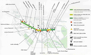
Promenade plantee map
promenade plantee map
Click on the image to have a larger view

Friday, August 5, 2011

Square du temple

History and description

The place was occupied by the Knights Templar, they were military and religious and were in charge to protect the pilgrims in the Holy Land;
In 1312, they were accused of heresy and suffered from repression, in 1314, several Knights Templar and the great master Jacques de Nolay were burned in the "Ile de la Cité.
Then, the place was occupied by the Order of Malta.
In 1667, a palace whose entrance is located at the entrance of the Square du temple was erected at the instigation of the Grand-Prior Jacques de Souvres.
The fortress became national property during the Revolution and was converted into a prison, the famous "prison of the Temple" (1792-1808) who was the last home of Louis XVI and the Dauphin Louis XVII.

The dungeon that had housed them was destroyed by order of Napoleon I in 1809, he wanted to erase all traces of the disastrous past.
Until 1853, the square was use as a convent, then a barracks, the place was destroyed and 12 years later,became the Paris garden that we know today.

In the square du temple, there are two gorgeous trees planted in 1882 and 1862 : a hazel (Corylus colurna) of 18m high and 1.85 m in circumference and a Japanese pagoda tree (Sophora japonica) of 17m high and 2 70 in circumference. The fauna is rich of birds of different species, like the Mandarin (native of southeast-Asia).
The Square du temple houses also an artificial waterfall, built with rocks from the Fontainebleau forest. its area is 7696 square meters and was opened in 1857 and redesign by Jean-Charles Alphand in 1865 (the same than the Park des buttes-chaumont).

In the square there is a bandstand from 1900.
There are 2 sculptures, 1 statue of the chansonnier Béranger (1780-1857) in stone (the first was a bronze statue and was destroyed, it was replaced by a stone one, and 1 bust;
Square+du+temple

There is also a stele with 85 children names. They were living in the 3rd arrondissement of Paris and were deported between 1942 and 1944, their age ranged from 2 months to 6 years old. The stele was inaugurated the 26th of October, 2007.

Location of the Square du temple
The square du temple is located in the 3rd arrondissement of Paris, the 64 rue de Bretagne 75003 PARIS


How to get to the square
You can use the Paris metro line, you will have to walk around 5 minutes:
-Paris metro line 3, temple station (the closest, less than 5 minutes)
-Paris metro line 3, line 11, Arts et métiers station (5 minutes).


Entrance fee and opening hours
From 1st to 30th of September: 9am to 8pm.
From May 1st to August 31th: 9am to 9pm.
From October 1st to October 28th: 9am to 6:30pm.


Square du temple map

Wednesday, August 3, 2011

Paris park, Parc Monceau

History and description
In 1769 the Duke of Chartres, purchased a piece of land (1ha), he built what will be called the "Folie de Chartres".
Later, Carmontelle a painter-architect-designer was in charge to draw the garden, he gave it an original and unique touch, with a mixing of all styles and all eras: the ruins of a temple of Mars, a Chinese pagoda, a Gothic castle, minaret, an Egyptian pyramid, a Chinese pagoda, a Dutch windmill, a Tartar tent, the park became famous because of those mixing.

The famous Naumachie, a basin surrounded by Corinthian columns (in Roman times it was a basin which was used for depictions of naval battles), was built.

In the park, there is a rotunda with columns, called the "flag of Chartres," alongside the boulevard de Courcelles, it was built by Ledoux.


The park became a national property during the Revolution, he was restored to the family of Orleans but in 1860, the City of Paris acquired it. The appearance of the park was then changed considerably.
The park was cut in half, one half was sold to the financial Pereire.
He erected many mansions on the east side, south and west, including Cernuschi Museum (Asian art) and Nissim de Camondo (18th century).
The design of the second half part was under the direction of the Baron Haussmann, the drawings of the park were changed for the last time by the engineer Jean-Charles Alphand, the architect Davioud and the horticulturalist Barillet-Deschamps (the same team than the Parc des Buttes-Chaumont) this team
In 1861, Napoleon III was finally able to inaugurate the parc Monceau.

The Parc Monceau is a 8.2ha Paris park, it's is full of different species of birds and children can enjoy the place, with sand box, skate rink, playground, swings and merry-go-ground...


There are also some statues:
-The ''Joueur de billes" stone statue (Charles Lenoir 1878)
-Guy de Maupassant bust (Raoul Verlet 1897)
-Alfred de Musset statue (Antonin Mercié 1906)
-Chopin statue (Jacques Froment-Meurice 1906)...

Location of the Paris park
The Parc Monceau is located in the 8th arrondissement of Paris, the 35 Boulevard Courcelles 75008 PARIS.


How to get to the Parc Monceau
You can use the Paris metro line:
-Paris metro line 2 Monceau station (best option)
-Paris metro line 3 Malesherbes station (around 7 minutes of walks)
-Villiers station (line 2 or line 3).


Entrance fee and opening hours
The park is open daily and is a free admission Paris park:
-from 7am to 10pm from the 1st of april until the end of the summer,
-from 7am to 8pm outside those times.


Paris park Parc Monceau map

Related Posts Plugin for WordPress, Blogger...